Subject: United States & Canada, Texas
Period: 1838 (dated)
Publication: Atlas Universel
Color: Hand Color
Size:
21.7 x 15.6 inches
55.1 x 39.6 cm
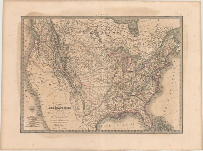
This is a great map filled with detail, Indian tribes, forts, and other political and geographical information. It covers primarily the United States, but extends to include a good portion of Canada, the western parts of which are largely still the domain of several Indian nations. The cartography in the west is primarily taken from the explorations of Lewis and Clark and dotted lines trace the Hunt and Stuart routes. Texas is an Independent Republic in its small format. Missouri Territory occupies all of the Midwest. The Pacific Northwest is labeled District de la Columbia, which stretches up into present-day British Columbia. Arkansas Territory is shown at its largest extent even though by the time of this publication it had already assumed its final borders. Two large lakes in today's Utah drain via rivers to the Pacific, as defined by dotted lines. The Colorado River ends in the desert east of San Diego and the title covers the Gulf of California. This interesting map was published by Colonel Pierre Lapie (1777-1850) and his son Alexandre Emile, who was the Royal Geographer to the King in Paris. The map was engraved by Pierre Tardieu, a foremost French 19th century engraver.
References:
Condition: B
Original outline color with light toning, a large damp stain covering most of the map, and light scattered foxing confined to the blank margins. There is a short centerfold separation in the bottom blank margin.