Subject: Holy Land
Period: 1876 (dated)
Publication: Atlas Universel
Color: Hand Color
Size:
18.4 x 24.6 inches
46.7 x 62.5 cm
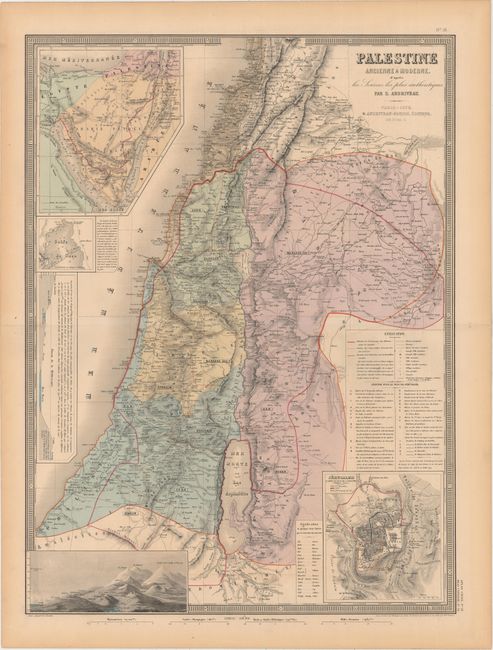
This map of the Holy Land is packed with detail. It delineates the area of the ancient land of the Hebrews before the Babylonian captivity, the locations of the Twelve Tribes of Israel, and the scope of Palestine under Roman rule. A key helps to identify roads, towns and cities (both ancient and modern), the remains of Roman roads, the caravan route from Egypt to Damascus and Damascus to Mecca, and more. An inset at top left details the Sinai Peninsula. Beneath this is a smaller inset of the Gulf of Suez and a comparison of the levels of various bodies of water in the area. At bottom left is a view comparing the elevations of mountains and other places in the region. A small key at bottom translates Arabic geographical terms into French. Jerusalem appears in plan form in an inset at bottom right with an extensive legend pointing out sites of interest. Printed by Chardon and engraved by Gerin, Rousset, and Fontaine.
References:
Condition: A
Original color with a hint of offsetting. There is a tiny edge tear at bottom, a centerfold separation at left, and toning, all confined to the blank margins.