Subject: Western Hemisphere - America
Period: 1697 (circa)
Publication:
Color: Hand Color
Size:
22.8 x 19.4 inches
57.9 x 49.3 cm
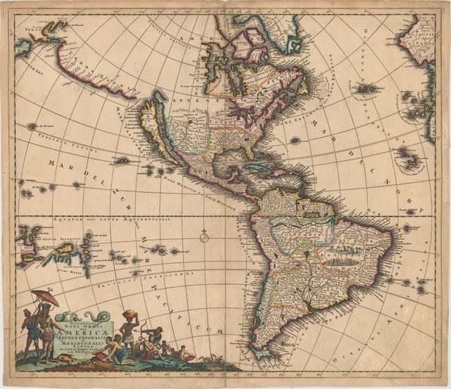
Second state of this beautiful map of the Americas and an interesting version in this series of maps inspired by Nicolas Visscher in 1658. Danckerts' map follows Sanson's geography for the interior of North America with open-ended Great Lakes, the island of California, and the R. del Norte being a confusion between the Rio Grande (with Santa Fe located near its source) and the Colorado River (emptying into the Mer Rurbrum). Added above California is a huge Terra Esonis stretching nearly to Japan, a bit of which is visible in the upper left border. There are dozens of place names along this spurious coastline. The cartography of South America is derived from De Wit and depicts the northern region overly wide. De Wit's tribal vignettes fill the interior of Brazil and Parime Lac appears on the Equator. One of the most interesting features of the map is the early appearance of Quiri Regio in the South Pacific, reflecting early Dutch exploration in the vicinity of Australia. This is the second state with nomenclature in Terra Esonis.
References: Burden #725; McLaughlin #123; Tooley (Amer) p. 124, #53.
Condition: B
A dark impression with attractive color on watermarked paper, light soiling, a crease at bottom left, and a tiny hole in Greenland. There are archival repairs to centerfold separations at top and bottom and to a 1" tear in Baffin Bay.