Subject: St. George's, Grenada
Period: 1762 (circa)
Publication: A General Topography of North America & West Indies...
Color: Hand Color
Size:
9.2 x 12.5 inches
23.4 x 31.8 cm
Thomas Jefferys was one of the most important English map publishers of the 18th century. His work included prints and maps of locations around the world, but his most notable maps are of North America and the West Indies. He began his career in the map trade in the early 1730s, working as an engraver for a variety of London publishers, and eventually setting up his own shop. In 1746, he was appointed Geographer to the Prince of Wales, and in 1760 he became Geographer to the King. These titles granted access to manuscripts and cartographic information held by the government. In the early 1760s he embarked on an ambitious project to produce a series of English county maps based on new surveys, but ran out of money and filed for bankruptcy in 1766. He then partnered with London publisher Robert Sayer, who reissued many of Jefferys plates and continued to issue new editions after Jefferys' death in 1771. Jefferys' American Atlas and the accompanying West-India Atlas, published post posthumously, are considered his most important cartographic works.
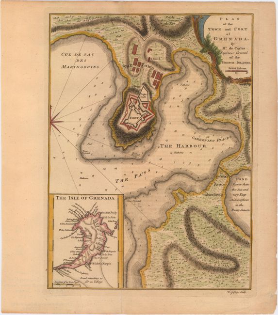
Fine plan of the harbor and town of St. George's. Details include soundings, anchorages, and shoals in the harbor, and the barracks, parade ground, church, and guard room in the fort. The map is fully engraved with vegetation and shows the location of an "Ancient Town abandond." Adjacent to the abandoned town is a pond that is noted as "lower than the sea and very deep which overflows in the rainy season." Also included is an inset map of the island identifying numerous points and rivers around the island, as well as a "bank extending as far as Tabago." The island is depicted as quite narrow and pointy at the southern tip. This map was published in The Natural and Civil History of the French Dominions in North and South America and A General Topography of North America & West Indies, both by Jefferys. This plan is almost twice the size of a similar plan published in London Magazine in 1762.
References:
Condition: B+
An excellent impression with light toning and offsetting from an opposing page of text.