Subject: Honduras, Belize & Guatemala
Period: 1775 (dated)
Publication: West-India Atlas
Color: Hand Color
Size:
25 x 18.6 inches
63.5 x 47.2 cm
Thomas Jefferys was one of the most important English map publishers of the 18th century. His work included prints and maps of locations around the world, but his most notable maps are of North America and the West Indies. He began his career in the map trade in the early 1730s, working as an engraver for a variety of London publishers, and eventually setting up his own shop. In 1746, he was appointed Geographer to the Prince of Wales, and in 1760 he became Geographer to the King. These titles granted access to manuscripts and cartographic information held by the government. In the early 1760s he embarked on an ambitious project to produce a series of English county maps based on new surveys, but ran out of money and filed for bankruptcy in 1766. He then partnered with London publisher Robert Sayer, who reissued many of Jefferys plates and continued to issue new editions after Jefferys' death in 1771. Jefferys' American Atlas and the accompanying West-India Atlas, published post posthumously, are considered his most important cartographic works.
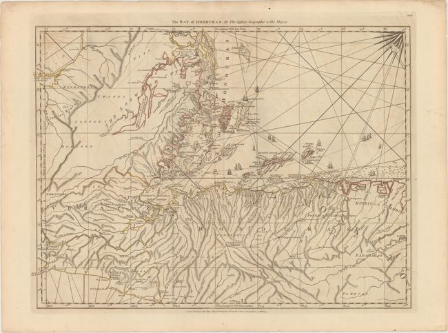
A finely detailed map of the Bay of Honduras including present-day Belize and much of Guatemala and Honduras. This area was hotly contested between England and Spain throughout the colonial period. The British logwood cutters were a constant thorn in the side of the Spanish and the cluster of camps at the mouth of the Belize River (Belize City today) was one of the most ransacked settlements in the new world. The map provides an excellent view of the tortuous Atlantic coastline and shows numerous channels, anchorages, soundings, keys, reefs, shoals and islands including the popular, present-day tourist destinations of Ambergris Caye and Roatan Island. Numerous English settlements are shown in The Logwood Cutters region and along the Mosquito Coast and a few roads are depicted. Several volcanoes are shown on the Pacific coast. This is sheet 10 of Jeffery's 16-sheet chart of the West Indies that formed the heart of the West-India Atlas.
References: Sellers & Van Ee #2131; Shirley (BL Atlases) M.JEF-4a #19.
Condition: B+
Watermarked paper with light offsetting.