Subject: Texas
Period: 1845 (dated)
Publication: New Universal Atlas
Color: Hand Color
Size:
14.5 x 12 inches
36.8 x 30.5 cm
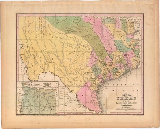
This is a very early map of the new state of Texas drawn by J.H. Young. It portrays early counties, towns, and villages and shows "Texas North of the Red River" in an inset at lower left. This panhandle extends north to the Green Mts., just west of Pikes or James Peak in present-day Colorado, and west to the Rio Grande River, thus incorporating Santa Fe and Taos. There is a comment taken from Arrowsmith's 1841 map in West Texas that the area "as far as North Canadian Fork was explored by Le Grand in 1833, [and] it is naturally fertile, well wooded, and with a fair proportion of water." San Patricio County occupies the south tip, while Bexar, Milam and Robertson counties take up the majority of the western region. Several early roads are depicted including the Presido Road, and Fort Alamo, mines, and the Presidios of Rio Grande, del Norte el de las Yuntas, del Paso del Norte are identified. This map was included in H.S. Tanner's New Universal Atlas published in 1845.
References: Day (TX) #108.
Condition: B+
Original color with a small amount of color offsetting to the left of the title cartouche and light toning primarily along sheet edges. There are several knife cuts along the platemark at top (far from the image) that have been archivally repaired.