Subject: World
Period: 1740 (dated)
Publication:
Color: Black & White
Size:
13.3 x 8.9 inches
33.8 x 22.6 cm
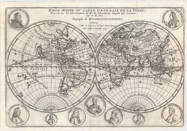
Fine double hemispheric map that features California as an island. Surrounding the hemispheres are nine medallion portraits of explorers, including La Salle, Tachard, Dampier, Magellan, Drake, Columbus, Vespucci, Marco Polo, and Schouten. The map shows early mapping of North America with the Great Lakes not completely formed. The northeast coast of Asia includes a coastline labeled Roye. de Coree stretching off the map in the direction of North America. Australia and New Zealand are tentatively drawn and named Nouvelle Hollande and Nouv. Zeeland. According to Shirley, this map may have been copied directly from the similar map by Mortier (see Shirley #572), however since the dating on the Mortier map is uncertain, it is possible that Mortier copied de Fer. This is a later edition by De Fer's son-in-law Guillaume Danet that is not noted in Shirley.
References: cf. Shirley #601.
Condition: B+
Issued folding on watermarked paper with some printer's ink residue at bottom, a faint stain at bottom right, and an archivally repaired tear that enters 1/4" into image at right. Narrow right margin.