Subject: World
Period: 1720 (circa)
Publication:
Color: Hand Color
Size:
21.7 x 19.1 inches
55.1 x 48.5 cm
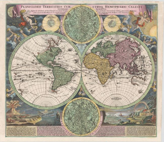
This is one of the most decorative eighteenth century world maps. The two hemispheres are surrounded by vivid engravings of natural phenomena such as waterspouts, a rainbow, earthquakes, and a volcano. Wind heads occupy the starry heavens, and two putti hold the title banner aloft. The map itself shows a typical geographical view of the period. California is shown as a peninsula with an indistinct Terra Esonis above it. There is a River of the West emptying into a small sea just northeast of California. The partial coastlines of Australia, New Zealand, and New Guinea are noted. Australia is shown to be separate from New Guinea, Carpentaria, and Diemens Land. Nova Britannia is shown as a separate island off the coast of New Guinea with the notation that it was discovered by Dampier in 1700. Several explorer's tracks are traced, including Magellan, Dampier, Tasman, Gaetani and Charmont. Nestled between the hemispheres are two detailed celestial maps. Text panels at bottom describe the natural phenomena. Homann borrowed both the cartography and depictions of natural phenomenon from Zurner's similar map circa 1700.
References:
Condition: B
On watermarked paper with some faint pencil markings, numerous worm holes that have been infilled with old paper, and a few professionally repaired tears, the longest of which measures 5", with a small amount of image replaced in facsimile. Remargined at bottom. Despite these faults, it presents well.