Subject: Southwestern United States
Period: 1855 (dated)
Publication: Railroad Surveys
Color: Black & White
Size:
75 x 26.5 inches
190.5 x 67.3 cm
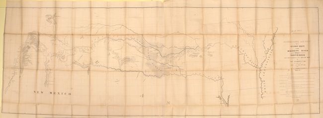
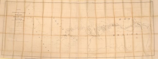
These are the larger maps that were included in the rare 8vo Pacific Railway atlas. They should not be confused with the same titled, smaller and much more common maps from the 4vo volume. This pair of matching maps are the result of the explorations and surveys of Lieut. A.W. Whipple and Lieut. J.C. Ives, Topographical Engineers, and A.H. Campbell, Civil Engineer. Wheat says Whipple "had demonstrated that the route which he had surveyed was practicable for a railroad, and the Santa Fe Railroad now traverses much of it … This is an important map, in its two parts, and reflects great credit upon Whipple and his entire party." The first map extends from the vicinity of Memphis and Vicksburg to the Rio Grande valley at Santa Fe and Albuquerque. Locates forts Arbuckle, Washita, Smith and numerous Indian villages. Drawn by A. Schimmelfinnig. Map No. 2 continues from Albuquerque westward to Los Angeles via Cajon Pass. Also locates forts, Indian lands, pueblos such as Zuni, and the gold and silver mines in New Mexico. Drawn by M. von Hippel. The route of the exploring parties is delineated on both with each camp site indicated. The size given is approximate for each map: together they are over 12 feet in length! These maps are uncommon and are rarely offered together.
References: Wheat (TMW) #872 & 873.
Condition: B
Issued folding with light offsetting, numerous short splits at fold intersections, and toning along the folds. Map No. 1 has a 3" binding tear at left.