Subject: United States, Texas
Period: 1848 (published)
Publication: HR Doc. #1, 30th Congress, 2nd Session
Color: Hand Color
Size:
33.4 x 13.8 inches
84.8 x 35.1 cm
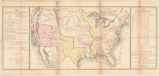
This map shows the new state of Texas with its northern boundary extending to 42 degrees N. latitude. Additional transitional territorial configurations are depicted, including a large California Territory extending nearly to Texas with a small version of New Mexico sandwiched in between. Within California are early references to the gold-related Nueva Helvetia and Sutter's Fort. Sometimes referred to as the 'Tables Map' because a table on each side of the map offers selected statistical information including details on the "Three Divisions" of Texas. The map contains interesting versions of treaty boundaries drawn and a table of explanations provides treaty dates. Wheat says the map was likely prepared for the General Land Office to show 1848 Guadeloupe-Hidalgo treaty lines. Hand coloring is used to indicate other treaty boundaries including Great Britain 1783; Spain 1795; France 1803; Spain 1819; Great Britain 1842 & 1846; and Mexico 1848. Lithographed by Duval in Philadelphia.
References: Streeter Sale (Vol. 6) #3876; Wheat (TMW) #561.
Condition: B
Issued folding with moderate toning along the folds and a few small spots. There are a number of short fold separations as well as a 2" binding tear at left, all of which have been archivally repaired. A binding trim at bottom left has been replaced with old paper.