Subject: Colonial Eastern United States & Canada, Great Lakes
Period: 1700 (circa)
Publication: Description de Tout l'Univers
Color: Hand Color
Size:
12.1 x 8.3 inches
30.7 x 21.1 cm
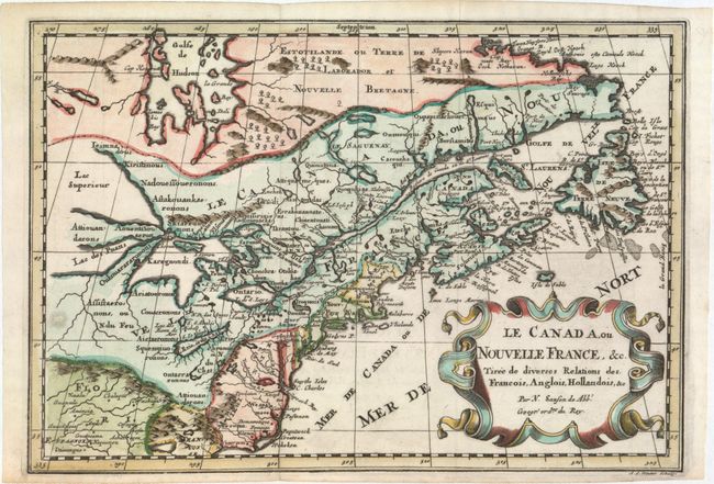
This is a reduced version of one of the most influential seventeenth century maps of the French and English colonies in North America. It concentrates on the region of greatest French interest. The entire Great Lakes basin and the St. Lawrence River are shown in great detail. The most important aspect of the map is the first appearance of L. Erie, ou du Chat as a recognizable lake on an atlas map. This delineation influenced the cartography of the region for more than 100 years and was not superceded until Delisle's "Carte du Canada" in 1703. The map is also an outstanding source for Indian tribal names and locations. Two names (Aouentsiouaeron and Attiouandarons) appear here for the first time. Lake Superior and Michigan (Lac du Puans) are left open-end to the west. Embellished with a nice title cartouche. Engraved by Anthony d'Winter.
References: Burden #575; Kershaw #137; McCorkle #683.6; Pastoureau, SANSON II F.
Condition: A
A dark, crisp impression. Issued folding with one small hole in a blank area of map at left that has been professionally repaired.