Subject: Galveston, Texas
Period: 1856 (dated)
Publication:
Color: Black & White
Size:
17 x 13.5 inches
43.2 x 34.3 cm
The Office of Coast Survey is the oldest U.S. scientific organization, dating from 1807 when Congress directed that a "survey of the coast" be carried out. By 1836, it was called the U.S. Coast Survey and in 1878, the name was changed to the U.S. Coast and Geodetic Survey. Today the Office of Coast Survey is a division of the National Oceanic and Atmospheric Administration NOAA.
The survey teams, composed of civilians as well as Army and Naval officers, charted the nation's waterways and produced a wide array of reports, survey charts, hydrographic studies of tides and currents, astronomical studies and observations, and coastal pilots. These charts are an important record of the changing nature of the nation's coastlines. In additional to coastal charts, the U.S. Coast and Geodetic Survey produced land sketches, Civil War battle maps, and the early aeronautical charts.
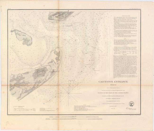
This coastal survey chart details the entrance to Galveston Bay. It includes a town plan of Galveston without streets named. The chart extends to Pelican Island, Bird Key, and Bolivar Point. It locates buoys, a beacon, a light boat, and is filled with soundings, bottom types and extensive notations on sailing directions. Triangulations were completed by R.H. Fauntleroy and J.S. Williams.
References:
Condition: B
Issued folding with light toning along the folds and one small hole at a fold intersection resulting in minute loss of image. There are a few other separations primarily in the margins that have been closed on verso with archival tape.