Subject: Colonial Southern United States
Period: 1705 (dated)
Publication: L'Atlas Curieux ou le Monde
Color: Hand Color
Size:
13 x 8.5 inches
33 x 21.6 cm
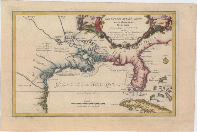
This interesting map focuses on the French explorations and discoveries in the Mississippi Valley and the Gulf Coast. Here, De Fer highlights information gleaned from the expeditions of La Salle and Iberville with the primary purpose of showing the progress of French exploration in the region. The map shows the basically correct relationship of the Mississippi River to Lake Pontchartrain and the Gulf of Mexico. La Salle had explored the Mississippi from the north in 1682-83 and returned by sea to establish a French colony in 1685. He missed the Mississippi delta and landed on the Texas coast, an error probably due to his inability to calculate longitude and because prominent maps of the period placed the mouth of the river far to the west of its true location. The site of La Salle's ill-fated colony near Matagorda Bay in modern-day Texas is shown and the title cartouche also dramatizes the explorer's tragic death at the hands of his own men. Engraved by Vincent de Ginville.
References: Day #1458; Lemmon, Magill & Wiese #12; Martin & Martin #13; Pastoureau, FER ID.
Condition: A
A nice impression on watermarked paper with good margins.