Subject: United States
Period: 1828 (dated)
Publication:
Color: Hand Color
Size:
28 x 21 inches
71.1 x 53.3 cm
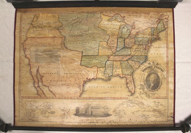
This early wall map of the United States extends to the Pacific. The Southwest and Texas are controlled by the United Mexican States which the map labels as the Internal Provinces of Mexico. Oregon is north of Mexico and runs east to the Continental Divide. The huge Missouri Territory stretches from Canada to Arkansas Territory. Arkansas, itself created from a portion of Missouri Territory, is in an early configuration with its western boundary to Texas' panhandle and locates Ft. Smith, Little Rock, Arkopolis, and Dwight. Chicago is shown south of its correct location. North West Territory reaches to Missouri Territory. A terrific distance table gives the mileage from Washington D.C. to each state's capital or largest city. Below the map is a fine elevation view of the "Capitol at Washington" with inset maps on either side: North America; City of New-York and Vicinity; District of Columbia; Boston and its' Vicinity; and the Caribbean with Cuba, Jamaica and St. Domingo. The title cartouche features a painstakingly detailed stipple engraving of George Washington. This is the first state of the second edition with Thrall's imprint replacing that of Huntington & Willard. Published in Hartford, Connecticut. A beautiful example of a scarce, early American-produced wall map.
References:
Condition: B
Professionally restored including mounting on new linen with fresh piping thread at sides. Attached to original wooden rods. Within the map are numerous small cracks and an occasional small chip which is now well supported on the new linen. The top margin has been replaced with old paper and there is some foxing near the bottom roller at right.