Subject: World
Period: 1784 (circa)
Publication: A Voyage to the Pacific Ocean
Color: Black & White
Size:
35.8 x 22.9 inches
90.9 x 58.2 cm
Captain James Cook (1728-1779) is best known for his three voyages to the Pacific (1768-71; 1772-75; and 1776-79). His discoveries radically changed the western understanding of the world in the late 18th century. He was the first to circumnavigate and chart New Zealand and provided the earliest European accounts of exploration along the eastern coast of Australia and the Hawaiian Islands. On February 14th, 1779, he was killed on Hawaii after attempting to kidnap the chief of the island.
Many contemporary accounts of Cook’s voyages, including charts and engravings, appeared in the late 18th century. The first official account of Cook’s first voyage was published in 1773 by John Hawkesworth in Volumes II and III of An Account of the Voyages Undertaken by the Order of His Present Majesty for Making Discoveries in the Southern Hemisphere... William Strahan and Thomas Cadell published the first official accounts of the second and third voyages in 1777 and 1784. Accounts of his exploration were subsequently translated into French, German, and Dutch.
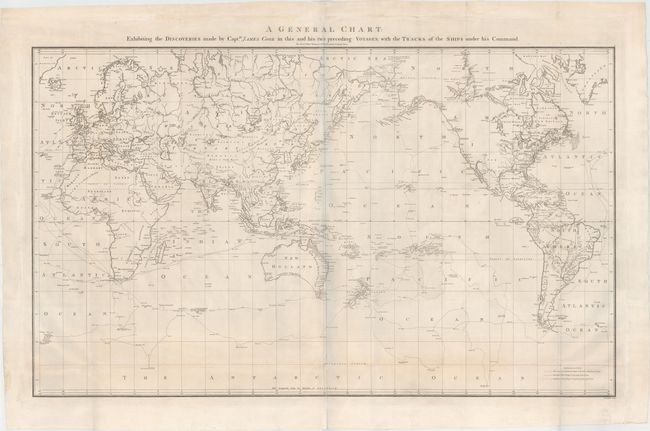
This large map on Mercator's projection was compiled by Lieut. Henry Roberts from Cook's surveys after the third expedition. The map is centered on Australasia with the routes of the Endeavour (1768-71) and Resolution (1772-75 and 1776-80) illustrated with occasional notes along the tracks. Roberts began his compilation under Cook's supervision and completed it after Cook's death. Inland detail is confined to river systems and a few place names. This map was used in the official account of the third voyage. Engraved by W. Palmer.
References: Perry & Prescott #1784-4; Falk #1784-4; Wagner #699; Tooley, p. 46 #331.
Condition: B+
Issued folding on sturdy paper with a "J. Whatman" watermark. There are a few short separations along folds that have been archivally repaired and very minor soiling. A nice example. The bluish shadow that appears along the centerfold is caused by our scanner and does not appear on the map.