Catalog Archive
Auction 149, Lot 126

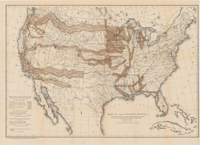
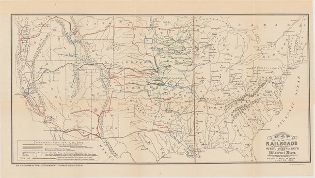
"[Lot of 2] Map of the United States Exhibiting the Grants of Lands Made by the General Government to Aid in the Construction of Railroads and Wagon Roads... [and] Map of the Railroads in Whole or in Part West, North or South of the Missouri River...", Donaldson, Thomas

Subject: United States

Period: 1883 (dated)

Publication: Public Domain

Color: Printed Color

Size:
See Description
Download High Resolution Image
(or just click on image to launch the Zoom viewer)

A. Map of the United States Exhibiting the Grants of Lands Made by the General Government to Aid in the Construction of Railroads and Wagon Roads. To June 30, 1883 (28.4 x 19.7"). This map was originally produced by the U.S. Gelogical Survey under the direction of John Wesley Powell and was reissued in Donaldson's Public Domain. Public Domain Land, the largest land give-away ever, was granted by Congress to 19th century railroad barons to pay for construction of the railroad lines. Most of these grants were west of the Mississippi River and ultimately totaled more than 174 million acres. The map itself depicts vast swaths of land granted to railroads, including virtually the entire state of Iowa. This is a somewhat misleading representation as most grants were for alternate sections of land along the route of the road. Additionally, the railroads were not able to sell all of these grants and many reverted back to the government. This is a historical and desirable railroad map that may have been the source for a map used in an 1884 campaign poster by Democrats claiming a giveaway of public lands to special interests. Condition: Issued folding with just a hint of toning and two unobtrusive edge tears in the top right corner that enter 3" into image and have been repaired on verso with archival tape. (B+)

B. Map of the Railroads in Whole or in Part West, North or South of the Missouri River... (24.3 x 12.3"). This map, also issued in Donaldson's Public Domain, shows the railroad lines west of the Missouri River that had received some sort of assistance from the United States. Assistance took the form of bond issuance and land subsidies, with the bulk being land grants. Condition: Issued folding with just a hint of toning and two tiny splits at fold intersections. A binding tear that enters 1.5" into image at right has been closed on verso with archival tape. (A)

References:

Condition:

See description above.

Estimate: $180 - $220

Sold for: $160

Closed on 5/21/2014

Archived