Subject: North America
Period: 1838-44 (dated)
Publication:
Color: Hand Color
The United States and Great Britain established in 1818 joint claim over the Oregon Territory - the region north of Spanish controlled Upper California up to the southern boundary of Russia's Alaska Territory at North latitude 54°40'. By the late 1830's this arrangement was beginning to fall apart.
In the 1840's the expansionist Democrats, including their 1844 presidential candidate, James Polk, claimed the entire region for the United States. Their expansionist desires were expressed by Polk's famous campaign slogan, "Fifty-four Forty or Fight!" The slogan also became a rally cry for Americans desiring to settle the territory. Following Polk's election, the dispute was resolved by the 1846 Treaty of Oregon, which struck a compromise that fixed the U.S./Canadian boundary at 49º North.
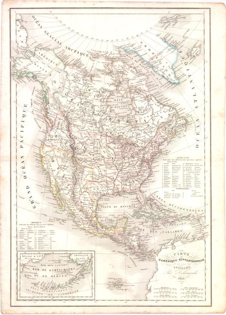
A. Carte de l'Amerique Septentrionale et des Antilles, dated 1844 (11.3 x 17"). Uncommon edition of this map of the continent with the Independent Republic of Texas and early western territorial borders in the United States. The District Oregon ou Colombie extends into present-day British Columbia and is bounded by the Rocky Mountains. Missouri Territory takes in the entire region between Oregon and the Mississippi except for the young states of Missouri, Arkansas and Louisiana. The map is filled with the locations of many Indian Districts and Tribes. The Aleutian Islands are shown in an inset on the same scale as the main map. A table at right lists 26 states and the territories of the United States, and another table lists 20 states for Mexico. Condition: Faint, scattered foxing primarily confined to blank margins.
B. Carte de l'Amerique Septentrionale, dated 1838 (11.3 x 16.3"). Attractive map of North America featuring an interesting territorial configuration during a very transitory period of the development of the United States boundaries. Oregon Territory is shown reaching high into present-day British Columbia at the latitude of 54°40'. Missouri Territory extends from the shores of Lake Michigan, south to the Red River and west to the Rockies. The entire Southwest is part of Mexico, with Texas named as a town inside the state of Saint Louis de Potosi. A small inset of the Aleutian islands is included in the bottom left corner. Condition: There are a few light spots in the image and light scattered foxing confined to the blank margins.
References:
Condition: B+
See description above.