Subject: Pacific Islands, Tahiti
Period: 1778-99 (circa)
Publication:
Color: Hand Color
Captain James Cook (1728-1779) is best known for his three voyages to the Pacific (1768-71; 1772-75; and 1776-79). His discoveries radically changed the western understanding of the world in the late 18th century. He was the first to circumnavigate and chart New Zealand and provided the earliest European accounts of exploration along the eastern coast of Australia and the Hawaiian Islands. On February 14th, 1779, he was killed on Hawaii after attempting to kidnap the chief of the island.
Many contemporary accounts of Cook’s voyages, including charts and engravings, appeared in the late 18th century. The first official account of Cook’s first voyage was published in 1773 by John Hawkesworth in Volumes II and III of An Account of the Voyages Undertaken by the Order of His Present Majesty for Making Discoveries in the Southern Hemisphere... William Strahan and Thomas Cadell published the first official accounts of the second and third voyages in 1777 and 1784. Accounts of his exploration were subsequently translated into French, German, and Dutch.
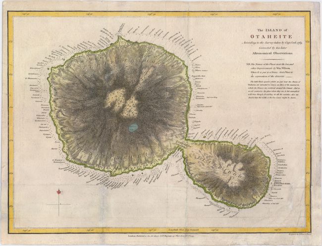
A. The Island of Otaheite According to the Survey Taken by Cap. Cook 1769, Corrected by His Later Astronomical Observations, from A Missionary Voyage to the Southern Pacific Ocean..., dated 1799, (15.2 x 11.2"). Copper engraved map of the island of Tahiti based on the survey of Capt. Cook and improved by William Wilson with the location of houses along the shores and the addition of numerous place names. A Curious Lake is located near the center of the large island. Condition: Issued folding, now pressed flat, with light soiling, and some extraneous creasing, especially in the bottom right corner. A few edge tears that enter into the neatline have been repaired on verso as well. A binding trim at bottom right has been replaced with old paper.
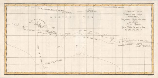
B. Carte des Isles Decouvertes aux Environs d'Otahiti, dans Plusieurs Voyages Faits Autour du Monde..., from Hawkesworth's Account of the Voyages, circa 1778, (20.4 x 9.7"). This is a chart that depicts the Society Islands, including Tahiti, and the tracks of Commodore Byron, Capt. Cook, Capt. Carteret, and Capt. Wallis. Drawn on a Mercator projection and engraved by Benard for the Paris edition of John Hawkesworth's Account of the Voyages. Condition: Issued folding on watermarked paper with four short fold separation that have been closed on verso with archival tape and some minor offsetting. The map has been remargined with old paper at top.
References:
Condition: B+
See description above.