Subject: Northwestern Italy & Southeastern France
Period: 1691 (dated)
Publication:
Color: Hand Color
Size:
24.7 x 31.4 inches
62.7 x 79.8 cm
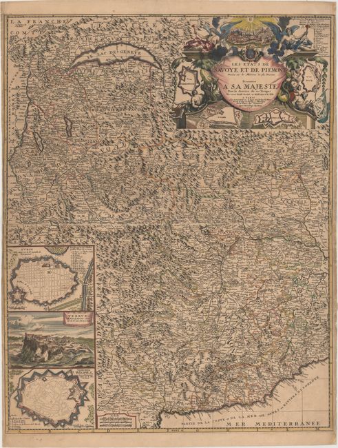
This large-scale map depicts the regions of Piedmont, Italy and Savoy, France during the Nine Years' War, also known as the War of the Grand Alliance or the War of the League of Augsburg. The map was published by Nolin and presented to King Louis XIV "for the service of his troops" and in celebration of French victories over Victor Amadeus II, the Duke of Savoy. The map is densely engraved with towns of various sizes, roads, political divisions, rivers, and graphic depictions of mountains and forested areas. At bottom left are three inset maps depicting bird's-eye plans of Turin and Vercelli and a view of the fortified town of Verrua, situated on the Po River between Turin and Casale. The striking title cartouche incorporates numerous elements highlighting French power and superiority. At top are triumphant angels of Fame flanking a view of Chambery, the capital of Savoy, illuminated by a sun representing the Sun King, Louis XIV. Below are chained prisoners, instruments of war, and symbols of the defeated enemies of the Grand Alliance, including an Imperial eagle, Dutch lion, and the python of rebellion. The composition is completed with bird's-eye plans of the fortifications of Nice and Montmelian in France and Carmagnole and Yvree in Italy, each taken by Louis XIV early in the war. Dated 1691 but published circa 1694.
References: Petto, p. 32.
Condition: B+
A dark impression with light toning, minor soiling, and a number of tiny tears that enter map border at right and left that have been archivally repaired.