Subject: Strait of Magellan
Period: 1706 (circa)
Publication:
Color: Hand Color
Size:
20.8 x 16.6 inches
52.8 x 42.2 cm
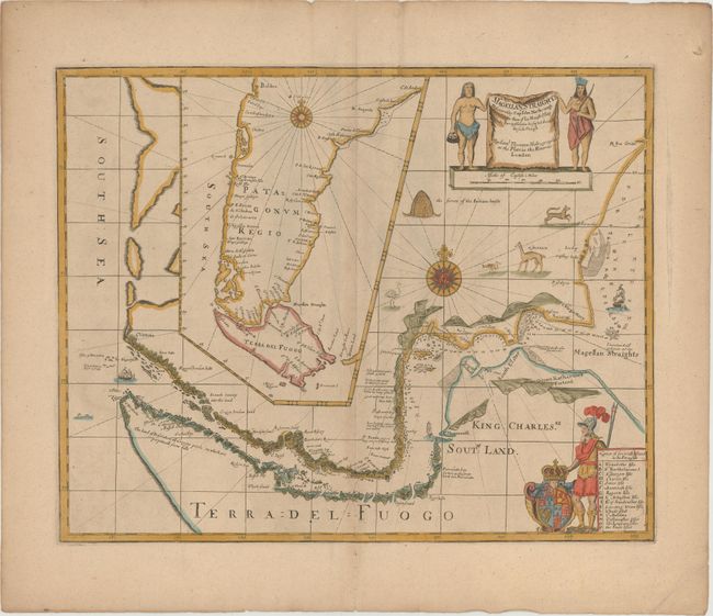
In 1670, John Narborough was the first Englishman to sail through the Strait of Magellan in both directions; thus demonstrating the falsity of the accepted wisdom that the wind and currents would prevent any eastward passage of the strait. He had been commissioned by James, Duke of York (later James II), to sail to South America to investigate potential trade possibilities. Narborough's expedition proved that a profitable trade with South America was possible, and this set the course of Britain's foreign policy for the next half century. Narborough published his journal of the voyage in An Account of Several Late Voyages… in 1694. His description of the Strait of Magellan provided the basis for British charts of the strait until the time of Captain Cook. This map is closely based on the map from Narborough's book, and provides a detailed view of the tortuous course of the strait with soundings and safe anchorages carefully noted. There are several notations along the coasts describing the countryside. A large inset map shows Patagonia and Tierra del Fuego. This re-issue was first published by John Thornton with the addition of numerous embellishments, including the English royal coat of arms of Charles II, a European soldier, Native Americans, ships, animals such as a rhea and guanaco, and a native American dwelling. Samuel Thornton, John Thornton's brother, took over John's business in 1706, and then re-published the map with his own imprint, as seen here.
Both the original Narborough map and the Thornton re-issues are extremely scarce. We have only found one record of either states of the Thornton map being on the market in the past 25 years.
References:
Condition: A
Wide, original margins with a hint of toning along centerfold. A very nice, clean example.