Catalog Archive
Auction 148, Lot 376

"Cuba Part of Chart E (Special Edition)", U.S. Coast & Geodetic Survey
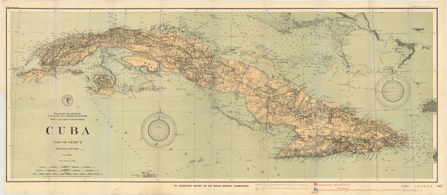
Subject: Cuba

Period: 1898 (dated)

Publication:

Color: Printed Color

Size:
41 x 17 inches
104.1 x 43.2 cm
Download High Resolution Image
(or just click on image to launch the Zoom viewer)

A large and very detailed U.S. Coast and Geodetic Survey chart printed as a special edition to accompany the report of the Major General Commanding giving information on the progress of the war in Cuba. Location and number of Spanish and Cuban troops given by overprinted flag and text. This example includes the Cayman Islands as well as some of the lower Bahamas. The detail is extraordinary, with hundreds of soundings as well as numerous roads and extensive topographical features on the land.

References:

Condition: A

Issued folding with very faint color offsetting and a short binding tear that just passes the neatline.

Estimate: $150 - $200

Sold for: $110

Closed on 2/19/2014

Archived