Subject: California & Baja Mexico
Period: 1772 (circa)
Publication: Diderot's Encyclopedie (Supplement)
Color: Hand Color
Size:
15.3 x 11.5 inches
38.9 x 29.2 cm
When Charles Joseph Panckoucke took over publication of Diderot's Encyclopedie in 1768, he promised to correct the cursory treatment of geography for which the first seventeen volumes had been criticized, with emphasis on the discoveries of the last 25 years. He employed Samuel Engel, a Swiss geographer, to write a series of articles about the northern regions and Didier Robert de Vaugondy to prepare ten maps to illustrate them. Engel rejected the De la Fonte Northwest Passage discoveries and believed the most sensible route from the Atlantic to the Pacific was along the north coast of Siberia. These maps illustrate the discoveries and various cartographic theories concerning the Pacific Northwest, East Asia and the North Pacific Ocean and include some of the most interesting comparative cartography of the eighteenth century
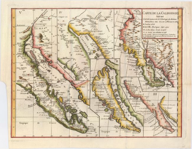
This sheet has five depictions of California that present a fascinating cartographic history of the region. It was one of ten maps compiled by Robert de Vaugondy for Diderot's important encyclopedia and depicts the mapping of California by five important cartographers. The earliest map reproduces Neron Pecci's manuscript map of 1604 showing the peninsula with a ragged coastline and place names derived from Cabrillo's voyage of 1542-3. The second map is a detail from Sanson's 1656 map showing the island of California with place names from the voyage of Vizcaino. Map three is from Delisle's map of America of 1700 with the question of California's insularity left open to interpretation. Next is Fra. Eusebio Kino's important map of 1705 that finally ended that cartographic myth. It is based on his overland expedition from the mainland to the Sea of Cortez. Finally, map five is a portion of a Spanish map, showing the Jesuit explorations, that first appeared in Miguel Venegas' Noticia de la California in 1757, which is the first published history of California. This is an essential map for any California map collection.
References: McLaughlin #241; Fite & Freeman #52; Heckrotte & Sweetkind #15; Pedley #474.
Condition: A
Nice impression on a clean sheet with minor printer's ink residue and a binding trim at lower left.