Subject: Oregon
Period: 1838-51 (circa)
Publication:
Color: Black & White
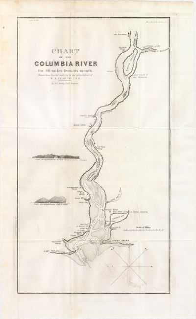
A. Chart of the Columbia River for 90 Miles from Its Mouth. Drawn from Several Surveys in the Possession of W.A. Slacum U.S.N., by M.C. Ewing, circa 1838 (9.1 x 16.3"). Detailed map of the river from Point Adams/Cape Disappointment east to Ft. Vancouver, showing villages along the way. The map shows the navigability of the river with soundings, sand bars and islands. It was drawn from several surveys in the possession of W. A. Slacum, USN. This is a companion map to Hood's map of the "United States Territory of Oregon, West of the Rocky Mountains." Ref: Claussen & Friis #222. Condition: Issued folding with a few minor spots and faint printer's ink residue. (B+)
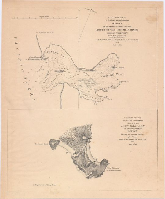
B. Sketch K Preliminary Survey of the Mouth of the Columbia River Oregon Territory [on sheet with] Sketch K No. 2 Cape Hancock (or Disappointment) Oregon..., by U.S. Coast Survey, dated 1850-51 (8.0 x 9.8"). Shows the entrance to the Columbia River with numerous soundings and hazards identified. On the same sheet is a proposed site for a new lighthouse at Cape Hancock. Condition: Light toning. (B+)
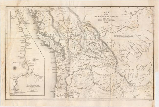
C. Map of the Oregon Territory from the Best Authorities, by Charles Wilkes, dated 1849 (13.1 x 8.3"). This is the reduced edition of Wilkes' map that was a major contribution to American cartography and the most detailed map of the region north of the Sacramento River. It provided Americans with an accurate view of an area still virtually unknown in the mid-nineteenth century. Wilkes supported the view of Senator Lewis Linn that the northwest boundary of America should be 54° 40' North, the famous 54-40 or Fight controversy. This map was used to illustrate that his claim was based on 'topographical' grounds and was instrumental in setting the scene for American interests in the territory. The map covers the region from Fraser's Fort and Fort St. James in British Columbia south to the upper Sacramento River, and from the Pacific coast to the Black Hills east of the Rocky Mountains. The map provides excellent detail of the region including dozens of forts, watershed and other place names. A large inset map "Columbia River Reduced from a survey made by the U.S. ex. Ex. 1841" depicts the river from Ft. Walla Walla to its mouth, where one of Wilkes' ships, the Peacock, was lost on the infamous Columbia Bar. It also features details of missions, Indian villages, and the major mountains. North is oriented to the left. Ref: Wheat (TMW) #655; Hayes 199. Condition: Issued folding with a few minor stains in the image and a binding trim at lower right. (B)
References:
Condition:
See descriptions above.