Subject: Necker Island & French Frigate Shoals
Period: 1797 (published)
Publication: Atlas du Voyage de la Perouse
Color: Black & White
Size:
27 x 19.4 inches
68.6 x 49.3 cm
Jean-Francois de Galoup, Comte de La Perouse commanded a French scientific expedition to the Pacific in 1785-88. Recognized as one the foremost naval commanders and navigators in France, he was selected by King Louis XVI to complete Captain James Cook's exploration of the western Pacific. The British Admiralty provided scientific equipment to measure variations in magnetic compass readings and with the latest instruments for determining longitude. La Perouse explored the coasts of the Gulf of Alaska and northwestern North America in search of the fabled Northwest Passage. After leaving America his expedition continued on to Asia where he explored from Macao to Kamchatka and the Solomon Islands in the South Pacific. La Perouse was meticulous in sending copies of his extensive logs, maps and surveying information via other ships as well as overland. La Perouse's last contact was in the spring of 1788 with a British ship in Botany Bay, Australia. The expedition was never heard from again. Considered one of the greatest French voyages, the French Government decided to publish the story of the expedition when it became clear they had been lost. An English edition was published in London.
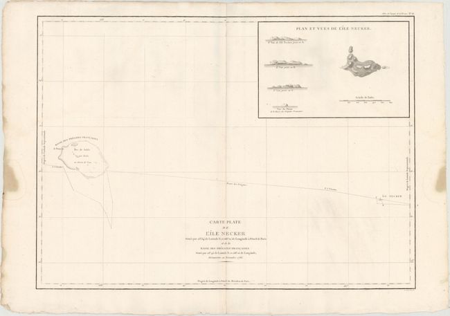
Sea chart of the Pacific Ocean depicting La Perouse's route between Necker Island, a northern island in the Hawaiian Group, to French Frigate Shoal. La Perouse discovered Necker Island on November 4, 1786. This famous French navigator sailed within a third of a league of the island on his passage westward, noting the perpendicular cliffs, white with the droppings of birds, the absence of trees, and the violence of the sea, which made it impossible to land. He called it Ile Necker, in honor of Monsieur Jacques Necker, French Minister of Finance under Louis XVI. A large inset shows a bird's-eye view of the topography of the island as well as four landfall approach views. Drawn by Herault.
References: Fitzpatrick, plt. 11.
Condition: A
A bright, watermarked sheet with minor printer's ink residue at bottom right, a small worm hole along centerfold at bottom of map, and several stains in blank margins, far from map.