Subject: Northern Florida
Period: 1837 (dated)
Publication: 25th Congress 2d. Session Doc. 11 No. 11
Color: Hand Color
Size:
23 x 8.4 inches
58.4 x 21.3 cm
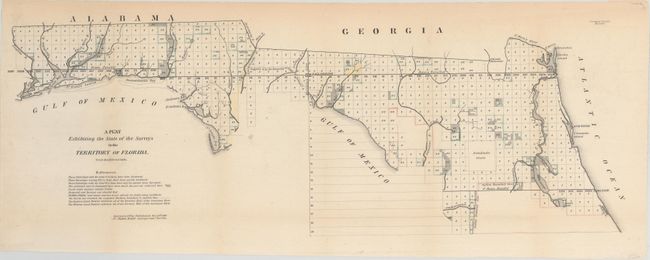
This map is one of the earliest to illustrate the status of public land surveys in the Eastern Land District (east of the Suwanee River) and the Western Land District (west of the Suwanee) in the Florida Panhandle. Survey efforts south of the Indian Boundary Line (marked in red/pink) in southern Florida were largely suspended due to the guerilla warfare of the ongoing Second Seminole War. St. Augustine, Amelia Island, and Tallahassee are named. In this early edition, the supposed boundary of the Forbes Purchase is uncolored and the legend notes that its limits are undefined. From the Surveyors Office in Tallahassee by Robert Butler, Surveyor General for the Territory of Florida. A very early edition of this chart.
References:
Condition: B+
Issued folding with a few short fold separations confined to the blank margins that have been closed on verso with archival materials and some minor toning, mostly along the sheet's edges and folds.