Catalog Archive
Auction 148, Lot 22

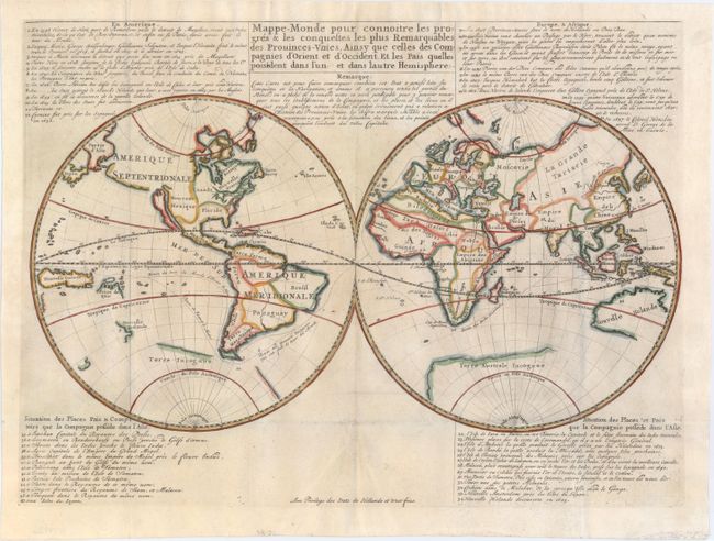
Scarce World Map Depicting the Voyages and Discoveries of the Dutch East India Company

"Mappe-Monde pour Connoitre les Progres & les Conquestes les Plus Remarquables des Prouinces-Unies, Ainsy que Celles des Compagnies d'Orient et d'Occident, et les Pais Quelles Possedent dans l'un et dans Lautre Hemisphere", Anon.

Subject: World

Period: 1670 (circa)

Publication:

Color: Hand Color

Size:
18 x 13.1 inches
45.7 x 33.3 cm
Download High Resolution Image
(or just click on image to launch the Zoom viewer)

The voyages and discoveries of the Dutch East India Company (VOC) and other Dutch trading companies are the subject of this handsome, double-hemisphere map of the world. California is shown as a prominent island, the Great Wall is shown in China, and the incomplete coasts of Australia and New Zealand are shown in the South Pacific. The principal countries are named and other locations are numbered and related to the keys above and below the map. The numbers 1 to 34 and the text refer to the voyages by Dutch explorers from 1594 (the first attempt to locate a Northeast Passage) to 1665 when New Holande (New York) was captured by the British. Items 35-47 describe the Dutch colonial possessions in Asia. Published by Jean Malherbe. Listed by Shirley as scarce.

References: Shirley #447.

Condition: B+

Issued folding, now pressed on watermarked paper with some minor creasing at bottom and a few small, professionally repaired fold separations.

Estimate: $700 - $900

Sold for: $375

Closed on 2/19/2014

Archived