Subject: Colonia Southeast United States
Period: 1740 (circa)
Publication: Grosser Atlas
Color: Hand Color
Size:
10.8 x 8 inches
27.4 x 20.3 cm
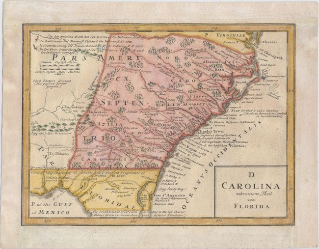
This map details the roads, forts, towns, and coastal shoals between the mouth of Chesapeake Bay to The South Bounds of Carolina according to the last Charter, which is in present-day Florida just south of St. Augustine. It extends inland to just west of the Apalaxy R. (Apalachicola River) and north to two battlefields of the Tuscarora War. The map was based off of Moll's map from Atlas Minor, circa 1729. As in Moll's map, the region of present-day Georgia is labeled Azilia for the aborted "Margravate of Azilia" of Sir Robert Montgomery. Seluda Desert, a remnant of the misconceptions perpetuated by John Lederer is also shown. Many of Moll's notations throughout the map have been translated into German and Latin. Several additions have also been made, including Ebenezer of the Salzb. at the mouth of the Savannah River, and Fort Col Angile (Argyle) near the mouth of the Howgeche (Ogeechee) River. This map was one of four separate maps printed on one sheet, titled Dominia Anglorum in America Septentrionali, showing the British possessions in North America based on Moll.
References: Cumming (SE) #233; Portinaro & Knirsch #123; Sellers & Van Ee #83.
Condition: B+
Professionally remargined with old paper at top, left, and right, with neatline at left replaced in facsimile. A nice impression with one tiny hole in border at right and an abrasion near the southern border of Carolina with a small portion of the image replaced in facsimile.