Subject: New England United States
Period: 1890 (published)
Publication:
Color: Black & White
Size:
35.5 x 17.8 inches
90.2 x 45.2 cm
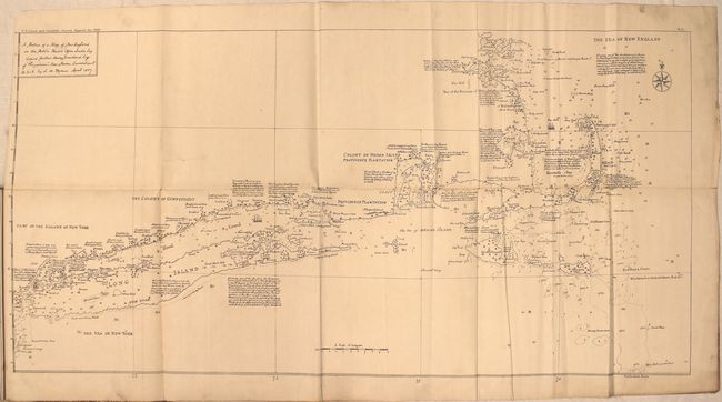
This rare and separately bound paper comes from the 1890 U.S. Coast & Geodetic Survey annual report. The short 3-page report includes the map mentioned above that was, according to Captain Charles Townshend, constructed by a British survey party between the years of 1715 and 1720. Of particular note, Townshend explains that "the chart furnishes positive proof of the existence of one of the closed passages that tradition says existed in early times through Cape Cod, and sustains the statement of Capt. Bartholomew Gosnold, in 1602, that Cape Cod was then an island." The map is packed with notes, soundings, shoals and anchorages.
References:
Condition: B+
Issued folding and mounted on linen to reinforce and repair a few short fold separations with light soiling in the blank margins. Text is toned and covers are very good with light wear.