Subject: United States, Texas
Period: 1846 (circa)
Publication:
Color: Hand Color
Size:
21.5 x 15 inches
54.6 x 38.1 cm
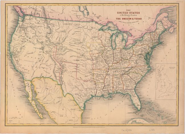
This interesting map depicts the United States in the midst of dramatic westward expansion, just after the annexation of Texas and the resolution of the Oregon Boundary Dispute, and just prior to the Mexican-American War. The map shows several previous and proposed western boundaries. In the Pacific Northwest there is the Line Proposed by the Convention of the 20th October 1818, the Line Proposed by the Americans in 1824 & 1826, and the Line Proposed by the English in 1826. The boundary is shown on the map as set by Oregon Treaty in 1846, but there is no mention of the treaty itself. The Line of the Treaty of Florida of the 22nd February 1819 and of 12th January 1828 forms the U.S. boundary with Mexico and the northern border of Texas. The Line Proposed to Mexico by the United Sates in 1835 shows an obscure proposed boundary roughly on the 37th parallel. Texas is shown in its largest configuration with the panhandle elongated to include the panhandle of present-day Oklahoma, and parts of New Mexico and Colorado. The Oregon Route is shown crossing the plains and the Rocky Mountains at South Pass. An inset of Great Britain is on the same scale in the Atlantic. This edition was published circa 1846 after the Oregon Boundary Dispute had been settled.
References: cf. Wheat (TMW) #503.
Condition: B+
Very light toning with a few edge tears with that have been closed on verso with archival material, only one of which enters 1" into the map image.