Subject: Western North America, California
Period: 1701 (published)
Publication: A System of Geography...
Color: Black & White
Size:
7.3 x 6.4 inches
18.5 x 16.3 cm
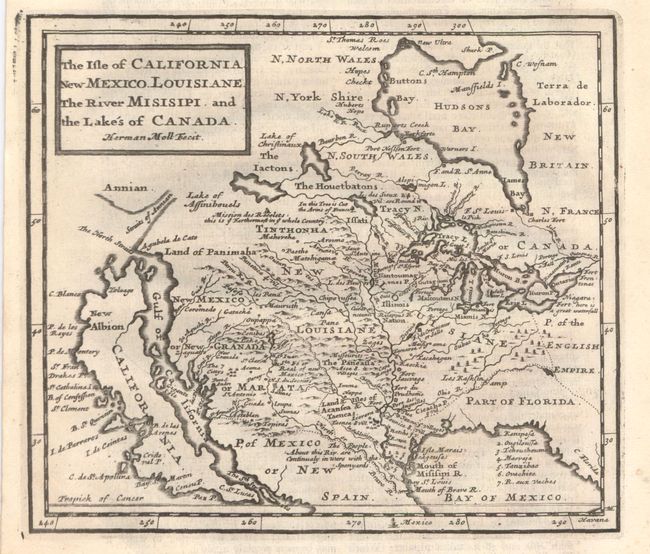
Herman Moll's map of the island of California and the western part of North America combines a lot of information with quite a bit of nonsense. Just north of California is The North Straits that separate the island from Agubela de Cato and the Land of Panimaha. Further north lies the Straits of Annian and the partial coastline of Annian. Four major rivers flow west into the Gulf of California with The 7 Cittys near the mouth of the Coral R., just west of Acoma. Conibas Lake forms the source of the North or Bravo R. (Rio Grande), which correctly empties into the Gulf of Mexico. Much of the map appears to have been derived from Hennepin, but it contains vastly more detail and the locations of numerous Indian villages, including the Missourits on the bank of what would become the Missouri River. Several forts are shown along the Mississippi River and in the Great Lakes region. In Canada, the Mission des Recolets is located just south of the Lake of Assinibouels, and is noted as ye Farthermost in ye whole Country. Another interesting notation shows a tree, near the headwaters of the Mississippi, into which the Arms of France are cut. On a full sheet of English text measuring 8.4 x 12.3".
References: McLaughlin #144; Tooley (Amer) p.129 #78; Wagner (NW) #487; Wheat (TMW) #81 & #109.
Condition: B+
A slightly uneven impression at left with some very minor soiling, little of which is in the image, and a small wormhole outside the neatline.