Catalog Archive
Auction 147, Lot 685

"[Lot of 2] Carte des Parties Nord et Est de l'Asie qui Comprend les Cotes de la Russie Asiatique le Kamschatka, le Jesso, et les Isles du Japon... [and] Carte des Nouvelles Decouvertes [on sheet with] Extrait d'une Carte Japonoise de l'Univers", Robert de Vaugondy, Didier

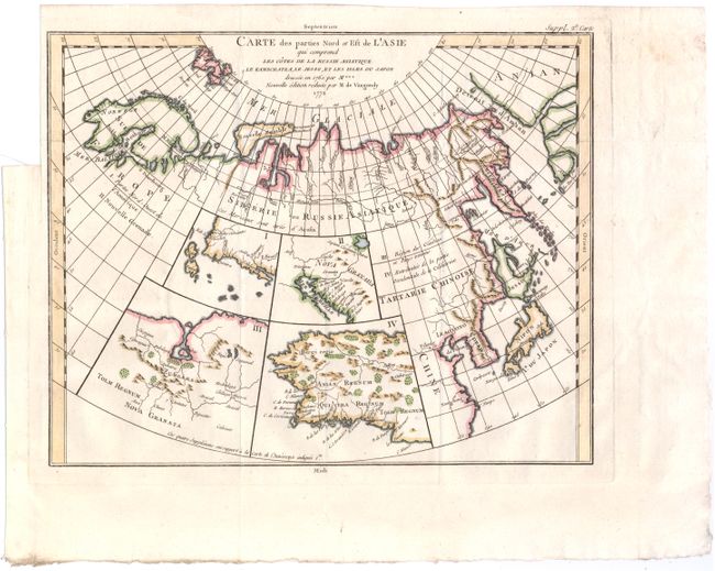
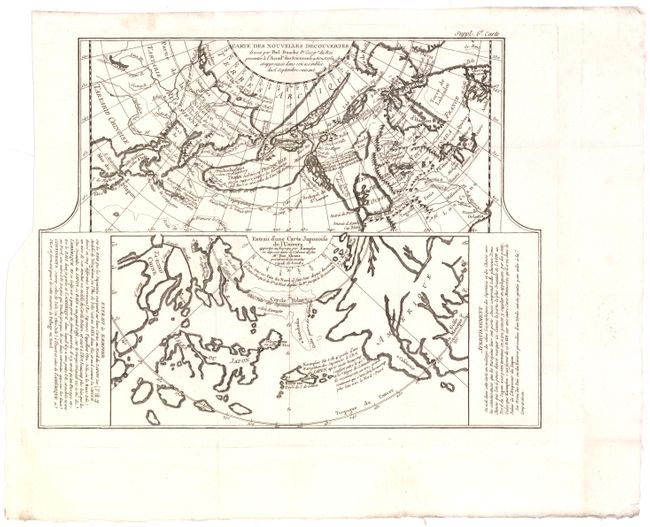
Subject: North Pacific Ocean, Asia, America

Period: 1772 (circa)

Publication: Diderot's Encyclopedie

Color:

Size:
See Description
Download High Resolution Image
(or just click on image to launch the Zoom viewer)

The Encyclopedie was published under the direction of Diderot from 1751 onward with thousands of articles written by the most prominent philosophers and scientists of the time. These great minds collaborated in the goal of assembling and disseminating the fruits of accumulated knowledge and learning. This massive reference work for the arts and sciences, served to propagate Enlightened ideas. Read a full description of this work and Diderot at Wikipedia.com.

A. Carte des Parties Nord et Est de l'Asie qui Comprend les Cotes de la Russie Asiatique le Kamschatka, le Jesso, et les Isles du Japon..., hand color (14.8 x 11.8"). This unusual map details the northern coastline of Russia (including Scandinavia), the eastern coast of Asia to below Nanking, and a bit of the coast of America called Anian. Inset into the map are four small maps of the western part of North America: I - Features the entire western coast with Japan just a short distance offshore; II - Focuses on Nova Granada showing the Mexican coast of the Gulf of California; III - Focuses on the Zubgara and Tolm Regnum of Nova Granada and the mythical seven cities of Cibola; and IV - Depicts Anian Regnum including Quivira Regnum and another Tolm Regnum. All together a fascinating view of some of the early cartographic theories concerning the western part of North America. Condition: Issued folding on watermarked paper with a binding trim at top left but still adequate room for framing.

B. Carte des Nouvelles Decouvertes [on sheet with] Extrait d'une Carte Japonoise de l'Univers, black & white (14.5 x 11.5"). Two very contrasting maps within a single border. Each map covers the north Pacific, including the continents bordering it. The top map depicts the theories of Philip Buache concerning the Northwest Passage, with numerous possible routes through North America, including Lace de Valasco, Lac de Fonte and Mer de l'Ouest. Alaska is shown as an elongated island. In Asia, Kamchatka is fairly well formed but Japan is still quite misshapen. The bottom chart depicts the region per Kaempfer, with Japan nicely detailed, but the coasts of both Asia and North America very deformed. Condition: A sharp impression, issued folding, with a binding trim at top left, a faint damp stain in bottom blank margin, and an archivally repaired fold separation not affecting map.

References: Pedley #406 & 452; Wagner (NW) #637, pp. 158-162; Kershaw #1230; McGuirk #146; Falk (AK) #1752-2

Condition: A

See descriptions above.

Estimate: $325 - $400

Sold for: $240

Closed on 11/20/2013

Archived