Subject: Africa
Period: 1749 (circa)
Publication:
Color: Hand Color
Size:
9.6 x 7.2 inches
24.4 x 18.3 cm
Thomas Jefferys was one of the most important English map publishers of the 18th century. His work included prints and maps of locations around the world, but his most notable maps are of North America and the West Indies. He began his career in the map trade in the early 1730s, working as an engraver for a variety of London publishers, and eventually setting up his own shop. In 1746, he was appointed Geographer to the Prince of Wales, and in 1760 he became Geographer to the King. These titles granted access to manuscripts and cartographic information held by the government. In the early 1760s he embarked on an ambitious project to produce a series of English county maps based on new surveys, but ran out of money and filed for bankruptcy in 1766. He then partnered with London publisher Robert Sayer, who reissued many of Jefferys plates and continued to issue new editions after Jefferys' death in 1771. Jefferys' American Atlas and the accompanying West-India Atlas, published post posthumously, are considered his most important cartographic works.
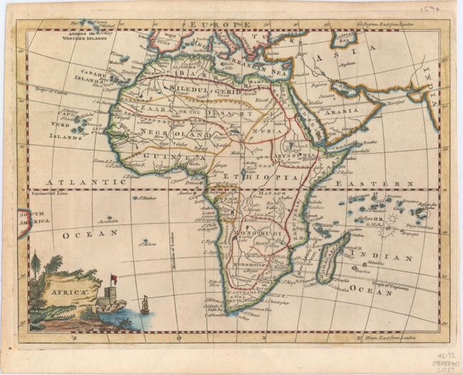
Interesting small map of the continent. The source of the Nile is in the correct vicinity, here called Nilehead and shown to be in Tzana Lake. Several regions are named, including Caffraria, Hottentots, and the Sahara, here labeled Zaara or the Desart. The twin lakes of Zaire and Zaflan are shown north of the Mountains of the Moon. The map stretches to include the eastern tip of South America, as well as parts of Europe and Asia, but these areas are largely left blank. A decorative title cartouche depicts a coastal scene complete with a crocodile.
References:
Condition: A
Issued folding.