Subject: Asia
Period: 1692 (circa)
Publication: Atlas Nouveau
Color: Hand Color
Size:
34.3 x 21.5 inches
87.1 x 54.6 cm
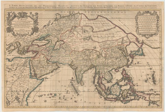
Originally a sculptor, Alexis-Hubert Jaillot began his career in map-making after marrying the daughter of Nicolas Berey. His skill as an engraver and his business acumen brought him to the attention of Nicolas Sanson's heirs, who hired him to breath new life into their business at about the same time that Blaeu's important printing works were destroyed by fire. Jaillot re-engraved Sanson's important maps on an enlarged scale and published them first in Paris and later printed by Pierre Mortier in Amsterdam. This expansive map of Asia is one of the largest and most impressive general maps of the continent. It is based on Sanson's 1650 map, but Jaillot updated the northeastern coastline from Duval's map of 1670. The island of Hokkaido is attached to the mainland as part of the Yupi peninsula and a huge Terre de Iesso (the name normally associated with Hokkaido) appears to the east. Korea is shown as an elongated peninsula. In the East Indies, New Guinea is divided into Terre de Papous and Nouvelle Guinee. Printed on two sheets and joined, as issued.
References: Yeo #76.
Condition: B
Issued folding, now pressed with creasing, light toning, and minor soiling. Short tears and chips in blank margins, and two tears at left and right that extend approximately 2" into map image, have all been professionally repaired. Backed in Japanese tissue to reinforce folds and repair several small holes at fold intersections.