Subject: Holy Island, Wales
Period: 1693 (circa)
Publication: Great Britain's Coasting Pilot
Color: Hand Color
Size:
22.1 x 17.4 inches
56.1 x 44.2 cm
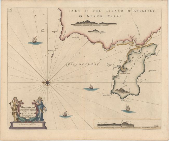
This very handsome chart shows Holy Island (historically known as Holyhead Island) and the western coast of the Isle of Anglesey. Only a few place names appear on the coast, including the town of Holyhead and Penthrine (Penrhyn). The chart shows good navigational detail, with soundings, anchorages, shoals, and rocks. A decorative compass rose orients the chart with north to the left, and four ships sail the surrounding waters. At bottom right is an inset with a coastal view of the islands of Anglesey and Holy. The decorative title cartouche features two female figures, one holding a cross and a chalice, and the other holding a serpent. The map is dedicated to Captain William Wright.
In 1681 Capt. Greenville Collins (fl.1669-1694) an officer in the Royal Navy was appointed by the Admiralty to make a complete survey of the coasts of Great Britain. Prior to this date the charts used by English mariners were copies of Dutch charts that had many inaccuracies. The task of surveying the entire coasts was formidable and took about 7 years, at the end of which only 46 surveys were finally used in an atlas titled "Great Britain's Coasting-Pilot Being a New and Exact Survey of the Sea-Coast of England," which was first published in 1693.
References: Shirley (BL Atlases) M.COLL-1 #18.
Condition: A
A nice impression with attractive color printed on heavy paper.