Subject: Gulf of Mexico and Caribbean
Period: 1800 (circa)
Publication:
Color: Hand Color
Size:
15.9 x 9.8 inches
40.4 x 24.9 cm
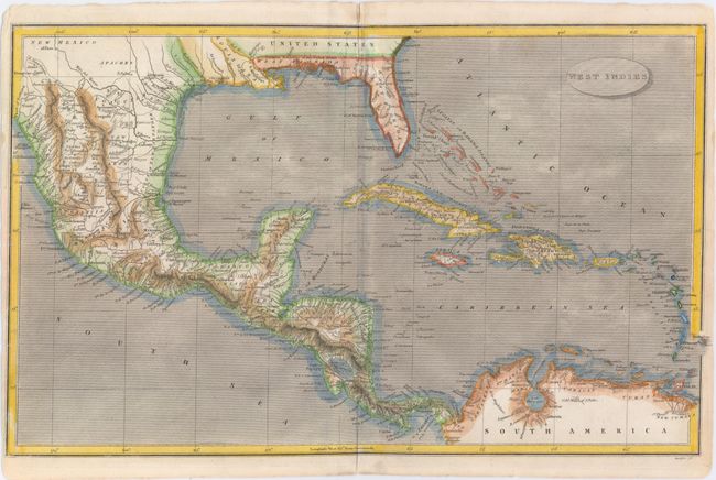
East and West Florida underwent several boundary and sovereignty changes during its history. The two regions were established in 1763 by the British colonial government out of land taken from France and Spain after the French and Indian War. Reasoning the newly acquired territory too large to govern, the British divided it into two new colonies separated by the Apalachicola River.
West Florida was based in Pensacola, and the colony included the part of formerly Spanish Florida west of the Apalachicola, plus the parts of French Louisiana taken by the British. Its northern boundary shifted several times over the years. East Florida has as its capital St. Augustine, which had been the capital of Spanish Florida.
Both remained loyal to the British crown during the Revolutionary War, and served as havens for Tories fleeing the Thirteen Colonies. In 1781 Spain invaded West Florida and captured Pensacola, leading Britain to cede both to Spain following the war. The ill defined boundaries led to a series of border disputes between Spain and the nascent United States known as the West Florida Controversy. Disagreements with the Spanish government led settlers along the gulf coast to declare the area the independent Republic of West Florida in 1810. The area was soon annexed by the United States, claiming the region as part of the Louisiana Purchase. The remainder of West Florida and all of East Florida were purchased by the United States in 1819 under the terms of the Adams–Onís Treaty. Florida Territory was formed as a result.
Interesting map of the Gulf of Mexico and Caribbean that covers the southernmost area of the United States, Mexico, Central America, the West Indies, and the northern coast of South America and shows towns, villages, topography, and watershed. Florida is divided into West Florida and East Florida, and the visible portion of Texas is labeled New Mexico. Within the region, El Paso, San Antonio, and Bexar are identified. Engraved by Harrison.
References:
Condition: B
There is a 0.5" tear that spans the centerfold in the middle of the map, and a few smaller edge tears that just enter image at left and right. Slight centerfold separations at the sheet's top and bottom do not enter the neatline; the upper separation has been closed on verso with nonarchival tape.