Subject: Western United States
Period: 1853-54 (dated)
Publication:
Color: Black & White
Size:
21.9 x 24.8 inches
55.6 x 63 cm
The Office of Coast Survey is the oldest U.S. scientific organization, dating from 1807 when Congress directed that a "survey of the coast" be carried out. By 1836, it was called the U.S. Coast Survey and in 1878, the name was changed to the U.S. Coast and Geodetic Survey. Today the Office of Coast Survey is a division of the National Oceanic and Atmospheric Administration NOAA.
The survey teams, composed of civilians as well as Army and Naval officers, charted the nation's waterways and produced a wide array of reports, survey charts, hydrographic studies of tides and currents, astronomical studies and observations, and coastal pilots. These charts are an important record of the changing nature of the nation's coastlines. In additional to coastal charts, the U.S. Coast and Geodetic Survey produced land sketches, Civil War battle maps, and the early aeronautical charts.
Two terrific charts from the first official scientific reconnaissance of the Pacific coast:
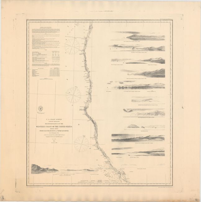
A. Reconnaissance of the Western Coast of the United States Middle Sheet from San Francisco to Umpquah River..., dated 1854. The chart delineates the coast from the entrance of San Francisco Bay at Points Lobos and Bonita north to show Bodega Bay, Mendocino City, Shelter Cove, Cape Mendocino, Trinidad, Crescent City, Port Orford, Cape Aragos and to above the mouth of the Umpquah River. The most impressive features are the twelve views of entrances and promontories along this rugged coastline, including Mendocino City Cove, Point Blanco, and the Entrance to San Francisco Bay. Geographical positions were determined by G. Davidson Assistant. Map made under the command of Lieut. James Alden U.S.N.
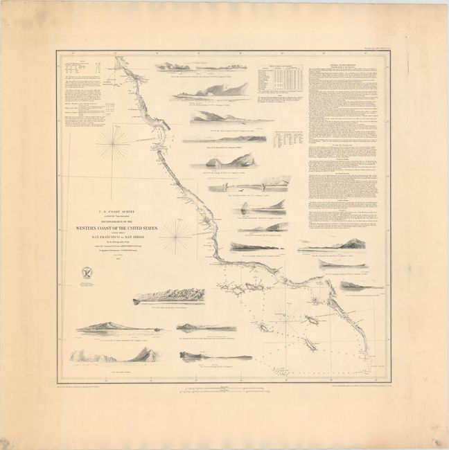
B. Reconnaissance of the Western Coast of the United States (Lower Sheet) from San Francisco to San Diego…, dated 1853. This map is one of three prepared by Lieutenant James Alden for this important survey. This sheet covers the region from the Mexican boundary to Point Reyes. It outlines the coastal littoral, shows dangerous reefs and shoals, gives offshore bathymetric soundings, plus general and specific harbor sailing instructions. The most impressive feature is the 17 views of entrances and promontories along this rugged coastline - among them Santa Barbara, Catalina Harbor, and the entrance to San Francisco Bay. The map was drawn by W.M. McMurtie and engraved by G. McCoy. Engraving of the views is also by McCoy and S.V. Hunt.
References: Heckrotte & Sweetkind #33.
Condition: A
Strong impressions on heavy paper with a bit of printer's ink residue confined to the blank margins. These two examples are uncommon issues as they are typically found issued folding on thin paper.