Subject: South Central United States
Period: 1825 (circa)
Publication: Atlas Universel
Color: Hand Color
Vandermaelen was the son of a wealthy industrialist who abandoned his father's business to follow a career in cartography. His goal was to produce the first atlas ever published in which every map was drawn on the same projection and to the same scale (1: 1,641,836), with each map covering an area of approximately 20 degrees of longitude (from Paris) and 6 degrees of latitude. Because of the consistent scale and projection, the maps could be joined together to form a huge globe that would measure over 25 feet in diameter. Vandermaelen had the only known globe constructed from his maps, requiring a special room for its display. It was also the first lithographic atlas ever published. There was one edition of the atlas, published in 1825-27, and the subscription list shows that only 810 copies were sold. Koeman called his Atlas Universel, "One of the most remarkable world atlases ever made. Far ahead of its time."
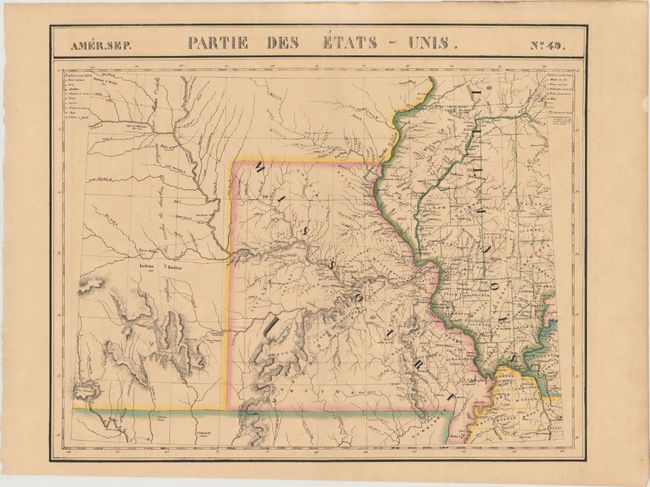
A. Amer. Sep. Partie des Etats-Unis. No. 49, (23.0 x 18.8"). This interesting map provides an excellent view of Missouri and Illinois with very early county development. The map is centered on the Missouri River, extending to the Platte and Omaha regions. There is excellent information on Indian Tribes and village populations, mineral deposits, explorers routes, etc. Condition: Light toning.
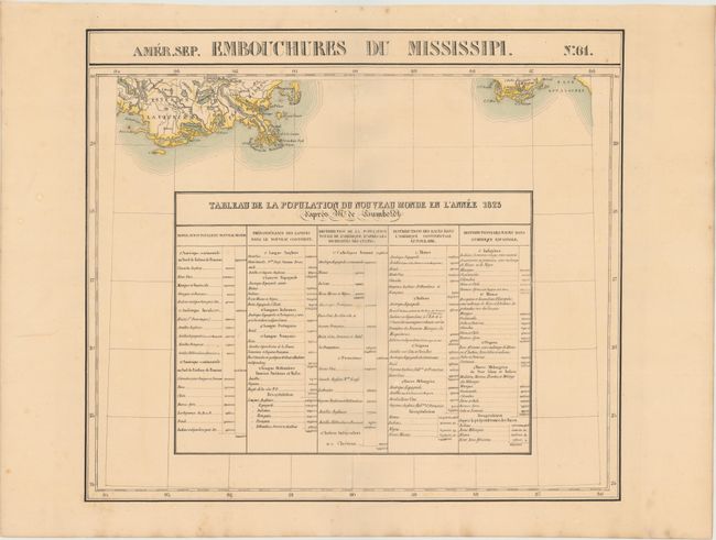
B. Amer. Sep. Embouchures du Mississipi No. 61, (20.6 x 18.3"). This rare chart details the delta of the Mississippi River south from New Orleans, and part of the Gulf coast at Apalachicola and the region just west of Mobile, including the Pascagoula area, Dog Island, Deer Island, St George, St. Joseph, St. Blas, Port St. Joe, and Apalachee Bay. Below the coastline is a large table "Tableau de la Population du Nouveau Monde en l'Annee 1823" which gives the population throughout the Western Hemisphere by race and religion. Condition: A few tiny spots in the image.
The Atlas Universel was the first atlas to present all the maps on the same scale (1: 1,641,836), with each map covering an area of approximately 20 degrees longitude (from Paris) and 6 degrees of latitude. It was also considered to be the first lithographic atlas ever published. The maps were meant to be joined together to form a huge globe measuring 7.775 meters in diameter. There was only one edition of the atlas, published in 1825-27, and the subscription list shows that only 810 copies were sold.
References:
Condition: B+
See description above.