Subject: Crete
Period: 1697 (circa)
Publication:
Color: Hand Color
Size:
47.2 x 17.9 inches
119.9 x 45.5 cm
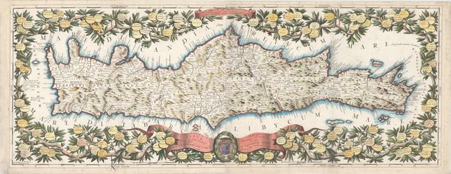
This stunning large-scale map of Crete shows the island divided into four regions: Canea, Rettimo, Candia, and Settia. The mountainous topography of the island is well depicted and dozens of small towns are named. The map is surrounded by an elaborate vine garland that is decorated with 100 medallions bearing the names of Cretan towns. The title is inscribed on a large ribbon banner, which also includes a dedication to Cardinal d'Estrees and the family coat of arms. This map was published in several of Coronelli's atlases, including Isolario Descrittione and Il Mediterraneo. There is evidence of a crack in the plate at bottom left. On two sheets, joined.
References: Zacharakis #677; Shirley (BL Atlases) T.CORO-6a #26-27 and T.CORO-13a #73-74.
Condition: B+
Issued folding, now pressed, on watermarked paper with minor soiling and several professionally repaired fold separations. There is a 5" tear adjacent to fold at left that has also been professionally repaired.