Subject: Western Europe
Period: 1712 (dated)
Publication:
Color: Hand Color
Size:
39.8 x 24.3 inches
101.1 x 61.7 cm
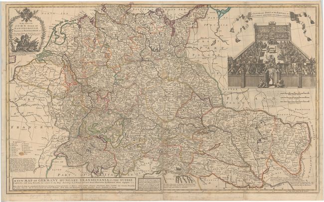
This large format map, printed and joined on two sheets, covers the entire German Empire from present day Netherlands and Belgium east to Hungary and Romania. The map is filled with detail including the locations of towns, abbeys, universities, rivers and mountains in profile. The map also shows the route of the Duke of Marlborough into Germany in 1704, during the War of the Spanish Succession, and a dedication cartouche at top shows the Duke on horseback crushing his rivals. Above the map is a large vignette titled The General Diet of the Empire... and shows members of both church and state in assembly from across the German Empire. The meeting is protected by a woman named "Defence of Liberty" who is perched above the doorway marked the "Liberty of Germany."
References:
Condition: B
Original outline color with several fold separations that have been closed on verso with archival material, an edge tear at bottom that extends 0.75" into the map image also closed on verso with archival material, one small brown spot in the explanation key, and some very faint pencil notations next to the vignette and in bottom blank margin.