Subject: Europe
Period: 1870 (dated)
Publication:
Color: Hand Color
Size:
15.4 x 9.8 inches
39.1 x 24.9 cm
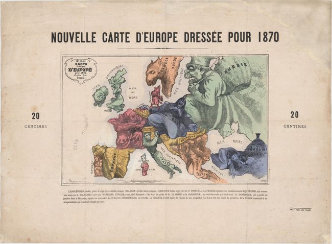
This rare satirical map was created by Paul Hadol, a French illustrator and caricaturist, at the outset of the Franco-Prussian War. Various countries and regions are represented by human and animal caricatures with props to help illustrate the situation. French text below the map describes each country's "character." Published in Paris by Vallee. The original price of 20 centimes is indicated at either side of the map.
At the center of the conflict are France and Prussia, with France depicted as a fierce, bearded soldier thwarting the advances of Prussia with a bayonet. Prussia appears as a stocky Otto von Bismarck with his hat pulled over his eyes and kneeling on Austria, a sleeping soldier, while his right hand completely covers Holland. England is shown as an enraged old woman with Ireland, a small bear, on a leash. The Balkans are represented by a man who is yawning and just beginning to awake. Russia is depicted as the bogey-man, trying to fill up his basket (with shadowy bear-like figures behind him). And both Spain and Turkey are shown as women, passively smoking and lounging.
Although the human personification of continents and countries can be seen as early as the 14th century (on maps by Opicinus de Canestris), human and animal metaphors on maps reached a new level in Europe between 1845 and 1945 with political cartoon maps. The rise of these satirical maps reflected the momentous political and cultural changes that occurred during the time. Political leaders were caricaturized and European nations were given symbolic identities that lent humor and accessibility to the geographical map. Based on popular stereotypes, these visual representations even found their way into the classroom to help bring geography and politics to life. Original serio-comic maps are very scarce due to their ephemeral nature.
References:
Condition: B+
Issued folding, now pressed with original color and light soiling. There are professional repairs to a few fold separations and tiny holes at fold intersections, as well as a large chip in blank margin at top right, far from image.