Catalog Archive
Auction 146, Lot 217

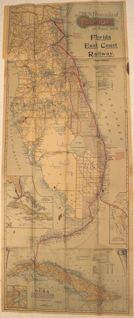
"Map of the Peninsula of Florida and Adjacent Islands", Matthews-Northrup Co

Subject: Florida

Period: 1914 (dated)

Publication:

Color: Printed Color

Size:
15.4 x 39.6 inches
39.1 x 100.6 cm
Download High Resolution Image
(or just click on image to launch the Zoom viewer)

This map of Florida shows the Flagler railroad system from Jacksonville to Miami and Key West, with steamboat connections to Havanna and Nassau. A table below the title shows the distances of the main line, branch lines, and lines under construction. County boundaries are depicted as well as cities, roads, canals, rivers and lakes. Includes inset at bottom "Map of Florida and the West Indies." Folds into tan paper covers.

References:

Condition: B

Issued folding with light toning, several small brown stains, and fold separations that are partially closed on verso with archival tape. The covers are lightly worn with a few small tears and chips.

Estimate: $275 - $350

Sold for: $275

Closed on 9/4/2013

Archived