Subject: Australia & East Indies
Period: 1867 (dated)
Publication: New Illustrated Family Atlas of the World
Color: Hand Color
Size:
17 x 22.5 inches
43.2 x 57.2 cm
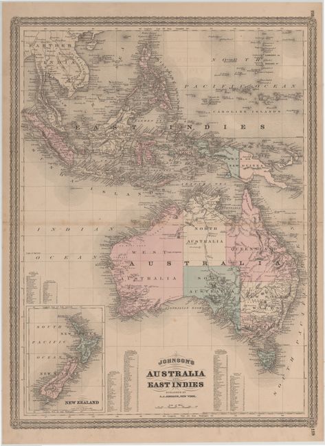
Very striking and colorful map shows Australia divided into seven states/territories including a huge Queensland, New South Wales, Victoria, Van Diemens Land, and West, North and South Australia. The southeast and southwest regions are more heavily settled than the rest of the continent, where only harbors are located around the coasts and little or no settlement appears in interior regions. An inset in lower left depicts New Zealand with its three islands named New Ulster, New Munster and New Leinster. Tables of the counties in Van Diemens Land, South Australia, West Australia, New South Wales, Queensland, and Victoria are also included, keyed to the map.
To the north of Australia lie the East Indies drawn in fine detail from the Gulf of Siam, Cambodia and Cochin China down to Sumatra, Java, Borneo, the Celebes Islands and the Philippines. Map also shows the Ladrone or Mariana Islands with Guam at their southernmost tip. The map also includes tables of counties in the Australian Commonwealth regions of New South Wales, Victoria, Queensland and Western Australia. The map is surrounded by decorative borders.
References: Tooley (Australia) p. 102 #754.
Condition: B+
Original color with light toning along centerfold, a couple of spots of foxing, and centerfold separations that just enter map border that have been closed on verso with archival tape.