Subject: Northwestern Africa
Period: 1661 (published)
Publication: Arcano Del Mare
Color: Black & White
Size:
29.5 x 19 inches
74.9 x 48.3 cm
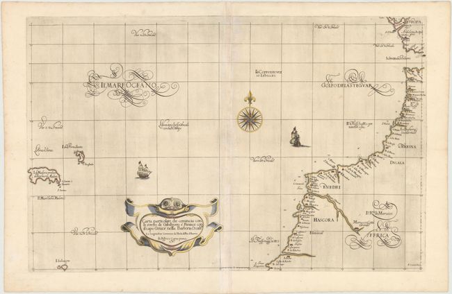
An elegant sea chart of the coastline of Morocco from Tanger to Agadir, and of Spain from Cadiz to the Strait of Gibraltar. Numerous place names are shown along the coast, as well as anchorages, soundings, and shoals. The chart extends west to include the islands of Madeira and Selvagens, and short navigational notes are included throughout. The chart is embellished with Dudley's trademark calligraphic style, a strapwork title cartouche with the head of a classic sea serpent, a large compass rose, and two sailing ships. This is the second edition with Lo. 6o. added to the title cartouche. Printed on two sheets, joined as issued.
Robert Dudley was the first Englishman to produce a sea atlas, Dell Arcano del Mare (Secrets of the Sea). A skilled mathematician and navigator, Dudley was exiled from England and settled in Florence where his atlas was published. He introduced a totally new style for sea charts in the atlas with only lines of latitude and longitude and no rhumb lines. The charts were meticulously compiled from original sources and were both scientific and accurate for the time. This important atlas was the first sea atlas of the whole world; the first to use Mercator's projection throughout; the earliest to show the prevailing winds, currents and magnetic deviation; and the first to expound the advantages of Great Circle Sailing. In an introductory leaf found in one copy in the British Library, the engraver states that he worked on the plates in seclusion for twelve years in an obscure Tuscan village, using no less than 5,000 pounds of copper for the printing plates. It was only issued in two editions and the maps are rarely seen on the market.
References: Shirley (BL Atlases) M.DUD-1b.
Condition: A
A nice impression on watermarked paper with wide, original margins and just a hint of discoloration along centerfold.