Subject: China, Korea & Japan
Period: 1797 (published)
Publication: Atlas du Voyage de La Perouse
Color: Hand Color
Size:
27 x 19.6 inches
68.6 x 49.8 cm
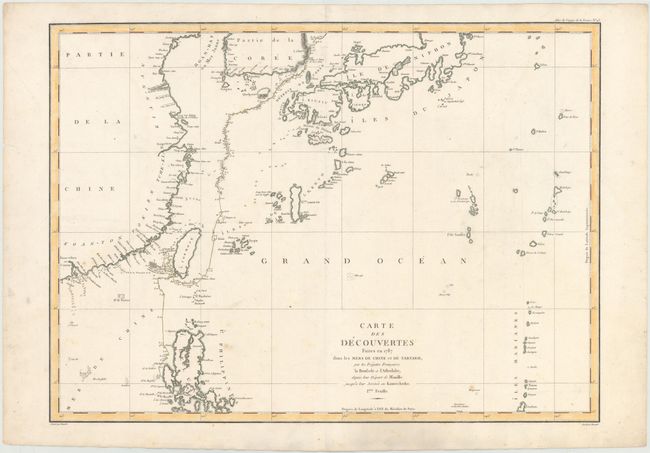
Jean-Francois de Galoup, Comte de La Perouse commanded a French scientific expedition to the Pacific in 1785-88. Recognized as one the foremost naval commanders and navigators in France, he was selected by King Louis XVI to complete Captain James Cook's exploration of the western Pacific. The British Admiralty provided scientific equipment to measure variations in magnetic compass readings and with the latest instruments for determining longitude. La Perouse explored the coasts of the Gulf of Alaska and northwestern North America in search of the fabled Northwest Passage. After leaving America his expedition continued on to Asia where he explored from Macao to Kamchatka and the Solomon Islands in the South Pacific. La Perouse was meticulous in sending copies of his extensive logs, maps and surveying information via other ships as well as overland. La Perouse's last contact was in the spring of 1788 with a British ship in Botany Bay, Australia. The expedition was never heard from again. Considered one of the greatest French voyages, the French Government decided to publish the story of the expedition when it became clear they had been lost. An English edition was published in London.
This is La Perouse's general chart of discovery for 1787 which represents the scope of exploration following his trip along the west coast of America. It covers the coastline from the tip of the Korean peninsula and Japan through the northern part of the Philippines. Numerous islands in the Pacific Ocean are named including Taiwan (Formose) and the Mariana group and Guam. The chart maps the last year of the La Perouse expedition and the ships Astrolabe and Boussole, showing very detailed soundings and all known harbors, straits, and island chains. The following spring the expedition vanished without a trace. This sheet covers his voyage from Manila to Korea. Drawn by Herault and engraved by Bouclet.
References: Shirley (BL Atlases) G-LPR-1a #43.
Condition: B+
Watermarked paper with some small scattered spots and several small worm holes in unengraved areas of the map that have been archivally repaired.