Subject: Orkney Islands, Scotland
Period: 1693 (circa)
Publication: Great Britain's Coasting-Pilot
Color: Hand Color
Size:
22 x 17.3 inches
55.9 x 43.9 cm
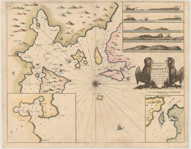
Very striking chart of the major harbors in the Orkney Islands off the northern coast of Scotland. The chart shows northeastern Mainland, Shapinsay, Roushay, Garsay, Wyre, and Egilsay. Two large insets depict Clestrain Sound and Deer Sound. There is good detail throughout of anchorages, soundings, shoals, currents, and navigational hazards. A number of coastal cities are named, and mountains are shown inland. The chart is adorned with a small ship and a compass rose orienting the chart with north to the right. The chart also includes five landfall approach views of Mulhead, Faire Isle, Maiden Papps and Dunkins Bay Head. The drape-style title cartouche is held aloft by two large sea birds, and includes a dedication to Captain Will Bond.
In 1681 Capt. Greenville Collins (fl.1669-1694) an officer in the Royal Navy was appointed by the Admiralty to make a complete survey of the coasts of Great Britain. Prior to this date the charts used by English mariners were copies of Dutch charts that had many inaccuracies. The task of surveying the entire coasts was formidable and took about 7 years, at the end of which only 46 surveys were finally used in an atlas titled "Great Britain's Coasting-Pilot Being a New and Exact Survey of the Sea-Coast of England," which was first published in 1693.
References: Shirley (BL Atlases) M.COLL-1 #43.
Condition: B+
Printed on heavy paper with light soiling and a few minute worm holes only visible when held to light.