Subject: Africa
Period: 1660 (dated)
Publication:
Color: Hand Color
Size:
22 x 17.3 inches
55.9 x 43.9 cm
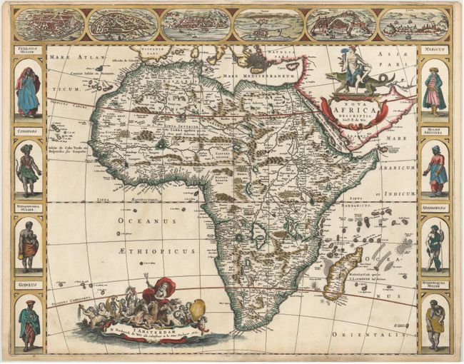
This is the rare first state of De Wit's map of Africa, published in 1660 in a set of maps of the four continents, each with decorative native figures at the sides and town views above. These were some of the earliest maps by De Wit, and also the last folio-sized maps with decorative borders to be issued in Amsterdam. This map shows views of Cairo (Alcair), Alexandria, Algiers (Alger), Tunis, Tangiers (Tanger), and Ceuta across the top, which are close copies from Jodocus Hondius' map of Africa from 1623. The figures at both sides of the map are nearly identical to those from Van den Keere's Africa map of 1614, with the exception of the top two (Congensis and Mulier Abissinea). The geography on the map is based on Jodocus Hondius' Africae nova Tabula from 1623, which was copied from Willem Blaeu's Africae nova Descriptio from 1617, although De Wit omits the engravings of animals in the interior. The Nile is shown according to Ptolemy with its sources arising in the lakes Zaire and Zaflan, the fictitious Lake Sachaf of Laurent Fries appears, as well as the R. de Spirito Santo. De Wit's map of Africa was issued separately, as well as in composite Dutch atlases.
References: Betz #96.1.
Condition: A
A stunning example with superb color, very minor soiling, and expert repairs to a centerfold separation at bottom and a couple of small worm holes in borders. The map has been remargined at bottom with old paper, with neatline expertly replaced in facsimile. The top margin is narrow.