Subject: Western Belgium
Period: 1570 (circa)
Publication:
Color: Black & White
Size:
20 x 15 inches
50.8 x 38.1 cm
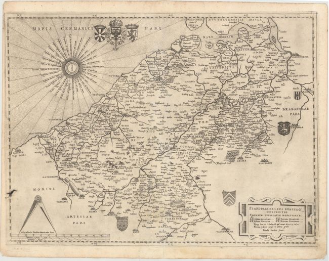
This map of Flanders in western Belgium was issued by Claudio Duchetti, the nephew and part heir to Antonio Lafreri and the successor to his business. Lafreri and Duchetti published their works in Rome, one of the map-making capitals of Europe during the sixteenth century. Although most of their northern counterparts still engraved maps on wood blocks, the Italian map makers preferred engraving on copperplates, resulting in superior workmanship. The Italians generally used the maps of their French and Germanic competitors as the sources of cartographical information when depicting regions outside of Italy, often not acknowledging credit to the original author. These Italian maps were typically issued separately, although composite atlases made to order began to be created sometime prior to 1570.
Duchetti's map is a close copy of a map of the same name engraved by Jacobus Bossius and published by Michaelo Tramezini of Venice, which in turn was based on Gerard Mercator's 4-sheet map of Flanders. The map extends from Calais (Caletum) in the west to Brussel (Bruxellae) in the east, and from Antwerp (Handouerpia) in the north to Lens and Valenciennes (Valentianae) in the south. Hundreds of towns of various sizes are shown in addition to the river systems in the region and a few topographical details. Abbeys and priories for both men and women are also identified on the map, with a key to their abbreviations listed in the strapwork title cartouche. A fine wind rose occupies the North Sea, and the map is further decorated with several coats of arms and a large pair of dividers atop the distance scale.
This map is extremely rare. We have found no examples of it being offered in the marketplace in the last 30 years, with the only existing examples in libraries and institutions.
References: Tooley (Italian Atlases of 16th Century) #205.
Condition: B+
Watermarked paper with a visible crack in the plate at lower left and a few spots of printer's ink residue. There are professional repairs to two short centerfold separations and a few small worm tracks and holes, with a minor amount of image along centerfold expertly replaced in facsimile.