Subject: Oklahoma
Period: 1876 (dated)
Publication:
Color: Black & White
Size:
32 x 24 inches
81.3 x 61 cm
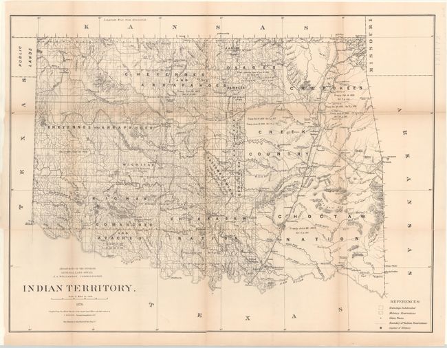
The uncommon first edition of the series of General Land Office maps delineating the status of lands allocated to various tribes. Indian removals from 'home lands' began as early as 1817 and in the years following many of the principal eastern Indian tribes were relocated. By 1879, the region was divided into a myriad of Indian nations and reservations, all but the smallest of which are annotated here with references to one or more treaties relating to their formation. The map is filled with fascinating detail of early forts, settlements, roads and trails. Less than fifty settlements appears outside of forts and Indian Agencies. The territorial capital is at Ockmulgee. Only a short portion of the panhandle is shown and labeled "Public Lands." There is no hint of any modern city but Greyson's is on the site of today's Tulsa. The Missouri, Kansas & Texas Railroad runs through the territory from Chetopa, Kansas to Denison, Texas and the Atlantic Pacific Railroad's proposed route is shown. Of particular interest are the many early roads and trails: Abilene Cattle Trail, Road to Arkansas City, Road from Cheyenne Agency to Camp Supply, Chisholm's Cattle Trail, Stage Road to Boggy Depot - to name just a few. There is a Negro Settlement well north of Ft. Arbuckle. Drawn by C. Roeser, Principle Draughtsman for the General Land Office. A scarce issue.
References:
Condition: B
Issued folding, now pressed and backed with tissue to reinforce and repair numerous fold separations. Light toning along the folds with a binding trim at lower left.