Subject: Massachusetts
Period: 1880 (published)
Publication: Contributions to the Geology of Eastern Massachusetts
Color: Printed Color
Size:
37.5 x 26 inches
95.3 x 66 cm
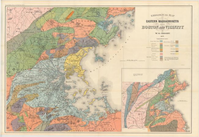
Large and very striking geological map that focuses on the vicinity around Boston. The region shown is bounded by the counties of Beverly, Wilmington, Dedham, and Hingham, parts of which are included. Large inset shows a larger region, extending further west to include Ashby, Westminster, Princeton and Oxford counties, north to Salisbury County, and south to include Mansfield, Easton, Bridgewater, and Kingston counties. Color legend locates nineteen different geological formations. A comment below the legend states that Shawmut Breccia, Amygdaloid, Primordial Slate and Conglomerate are not distinguished on this small scale map.
The map is accompanied by the report Contributions to the Geology of Eastern Massachusetts. Octavo, paperback with gray wrappers. 285 pp. with five additional geologic plates. Map is enclosed with the original envelope labeled "Occasional Papers of the Boston Society of Natural History - Vol. III Map." An uncommon issue that was created by W.O. Crosby.
References:
Condition: A+
Condition code is for the map, which is fine. Text is lightly toned with deckled edges and a few minor chips. Covers are heavily worn and toned, with the back paper cover almost detached.