Subject: South Central United States
Period: 1866 (dated)
Publication:
Color: Printed Color
Size:
38.2 x 25 inches
97 x 63.5 cm
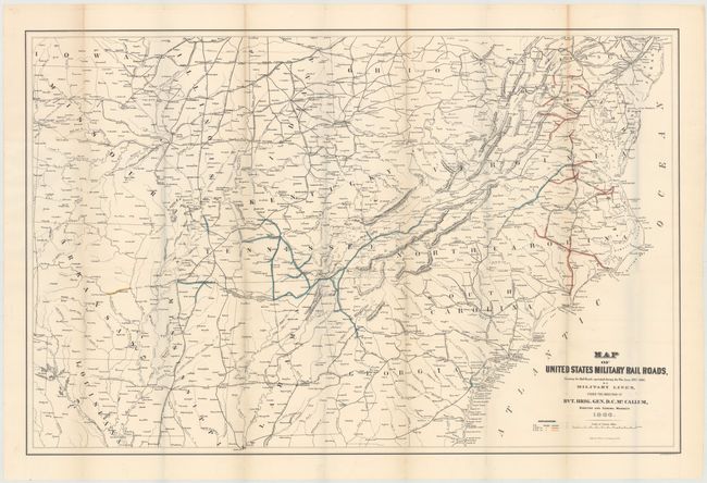
Interesting map produced the year following the close of the Civil War showing the military railroads under the command of Union General McCallum. It provides a clear picture of the railroads involved in the theater of operations during the Civil War. The map is filled with named railroads and stations. The legend uses color to delineate the various rail gauges throughout the map including 5 ft., 4 ft. 8 1/2 in., and 5 ft. 6 in. gauges. The map is centered on Tennessee and extends northward to show much of Pennsylvania, Ohio, Indiana, and Illinois. To the west is Missouri, with parts of Arkansas and Louisiana, but not to the Gulf Coast. It is filled with place names including some errors like Marks Corner for Moncks Corner, South Carolina. Good detail along the Atlantic coast. The scale is large enough to easily track military operations and troop movements.
References:
Condition: B+
Issued folding with a few tiny separations at fold intersections, some faint toning along folds, and minor offsetting. Two fold separations in top margin, one of which just enters neatline, have been closed with archival tape.